
The Galveston Bay Barrier System, also known locally as “Ike Dike,” is a network of gates, levees, dunes, and flood barriers designed to defend the upper Texas Gulf Coast from catastrophic storm surge. It is the centerpiece of the Coastal Texas Project, the largest coastal protection effort in U.S. history.
The Origin of the Name “Ike Dike”
“Ike Dike” is a term first coined in 2008 after Hurricane Ike. Dr. Bill Merrell of Texas A&M University at Galveston proposed the concept of a coastal barrier system to protect the Houston-Galveston region. Merrell coined the name as a direct reference to Hurricane Ike. The earliest public mentions of the term appeared in late 2008 and early 2009 during interviews and local news coverage of Merrell’s proposal.
Hurricane Ike Makes Landfall on the Texas Gulf Coast
On Sept. 13, 2008, Hurricane Ike made landfall near Galveston Island as a large Category 2 storm, driving a wall of water across Bolivar Peninsula, Galveston Bay, and deep into the Houston metropolitan area. The storm caused an estimated $29.5 billion in damage and killed 103 people. It also exposed how vulnerable the Houston-Galveston region is to large-scale coastal storm surge.
From Disaster to Design: Ike Dike is Born
The concept of a coastal storm risk management project for the Houston-Galveston region gained momentum as the U.S. Army Corps of Engineers (USACE) completed its critical six-year feasibility study following Hurricane Ike. And in December 2022, Congress formally authorized the Coastal Texas Protection and Restoration Project, or Coastal Texas Project, which is a combination of several ideas that include hard infrastructure like the “Ike Dike” with natural barriers like beach and dune restoration.
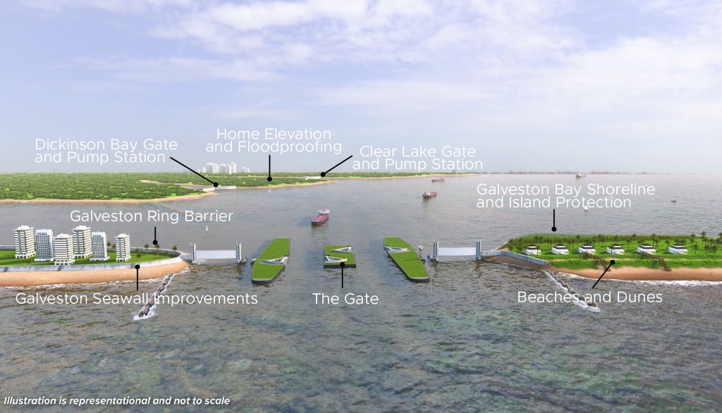
How the Ike Dike Works: Seven Features of the Galveston Bay Barrier System
The Galveston Bay Barrier System includes seven features. Together, they form what the U.S. Army Corps of Engineers (USACE) commonly calls the Coastal Spine, an integrated system of hard infrastructure such as gates, levees, and pump stations with natural barriers such as beach and dune restoration.
1. The Gate
The centerpiece of the Ike Dike is The Gate (Bolivar Roads Gate System), a large barrier spanning the two-mile-wide pass between Galveston Island and Bolivar Peninsula. When a storm surge barrier closes, it physically blocks the inflow of seawater from the Gulf — and here’s how that stops flooding.
During a hurricane, powerful winds and low atmospheric pressure push enormous volumes of ocean water ahead of the storm toward shore. This wall of water, called storm surge, is not a wave — it is a sustained rise in sea level that can push miles inland through any open waterway. For the Houston-Galveston region, Bolivar Roads is the primary open door: a two-mile-wide pass between Galveston Island and Bolivar Peninsula through which the Gulf of America connects directly to Galveston Bay and the communities, ports, and infrastructure surrounding it.
The Gate closes that door. When National Hurricane Center forecasts indicate a storm surge threat, The Gate would be deployed across the pass, creating a continuous barrier between the Gulf and the Bay. With the pass sealed, surge-driven seawater has no primary entry point into Galveston Bay. The water still rises on the Gulf side of the barrier — but it cannot push through into the Bay, up the Ship Channel, or into the neighborhoods, refineries, and medical facilities that line the shoreline.
Under normal conditions, The Gate remains open, allowing tidal flow, commercial shipping, and recreational vessel traffic to pass freely. It is designed to close only when a storm demands it, then reopen once the threat passes. Pump stations built into the system handle water already inside the Bay from rainfall, moving it out once the gate reopens.
Without a barrier, a major storm making landfall at Bolivar Roads would push surge directly into one of the most economically significant industrial corridors in the United States. Hurricane Ike demonstrated this in 2008, when unobstructed surge swept across Bolivar Peninsula, filled Galveston Bay, and penetrated deep into the Houston metro area — causing nearly $30 billion in damage from water alone.
Engineering design is currently underway for this feature.
2. Beaches and Dunes
Along the Bolivar Peninsula and West Galveston Island, this nature-based feature restores and widens natural coastal barriers through beach nourishment, dune construction, and vegetation planting.
As of 2026, this feature is also in engineering design.
3. Galveston Seawall Improvements
The historic Galveston Seawall, which has protected the city since the early 1900s, could receive structural upgrades to increase its resilience against storm surge and wave energy, extending its protection across 10 miles of coastline.
This feature currently awaits funding for engineering design.
4. Galveston Ring Barrier
The proposed ring barrier is a system of floodwalls, gates, pump stations, and levees that would provide flood risk management for approximately 15.8 square miles of the City of Galveston. The maximum height of the floodwall was recommended to be 14 feet, and it could contain numerous gates across roadways and railways, including a gated closure at Offatts Bayou. The gates would remain open until the system needs to be closed for storms. Drainage structures and pumping stations are included in the plan to remove excess water from the system.
This feature currently awaits funding for engineering design.
5. Dickinson Bay Gate and Pump Station
At the entrance into Dickinson Bay, the plan calls for a 100-foot-wide floating sector gate. A pump station would be constructed to help draw off water coming from the watershed due to rainfall and pump it out to the bay. The pumping station will have a designed capacity of 19,500 cubic feet per seconds. The entire proposed structure would start on the west side of State Highway 146, near Avenue T, and end on the south side of the bayou, near Waterman’s Harbor west of State Highway 146.
This feature currently awaits funding for engineering design.
6. Clear Lake Gate and Pump Station
The plan includes the construction of a 75-foot floating sector gate in the southernmost inlet to accommodate boat traffic into and out of Clear Lake. To the right and left of the sector gate, it is proposed to add circulation gates to address potential water quality concerns and assure tidal flow between the inlet and Clear Lake. In the northernmost inlet, a pump station would be needed so that, when the gates are closed, water coming down from the watershed due to rainfall will be pumped out to the Bay. The proposed floodwall and closure structure would start on the west side of State Highway 146, near NASA Road 1, and end on the south side of the outlet, near Marina Bay Drive west of State Highway 146.
This feature currently awaits funding for engineering design.
7. Home Elevation and Floodproofing
For properties where structural barriers alone are not sufficient, this feature funds the elevation and floodproofing of individual homes, providing a direct, community-level line of defense against storm surge risk.
This feature currently awaits funding for engineering design.
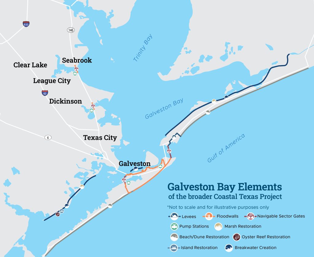
Where is Ike Dike Located?
The Galveston Bay Barrier System is centered on Galveston Bay and the coastlines that shape the bay’s entrance from the Gulf of America. Its most prominent feature, The Gate, is planned for Bolivar Roads, the waterway between Galveston Island and Bolivar Peninsula.
Within the Coastal Texas Project, Ike Dike is one of two major Galveston Bay elements. The other, Galveston Bay Shoreline and Island Protection, is located mostly in Galveston County between Chocolate Bay and High Island, along 34 miles of Gulf Intracoastal Waterway shoreline.
Current Status of Ike Dike
Ike Dike is moving forward, starting with design work for its first major features. Working alongside USACE and the Texas General Land Office, GCPD is the local non-federal sponsor, helping advance the project through funding coordination, engineering design, regulatory coordination and long-term planning.
Coastal Texas Project Milestones
- 2008: Hurricane Ike caused nearly $30 billion is direct damages and $150 billion in total economic disruptions, scraping Bolivar Peninsula bare. Dr. Bill Merrell of Texas A&M at Galveston proposes a coastal barrier system concept and coins the term “Ike Dike.”
- 2015: U.S. Army Corps of Engineers conducts a feasibility study of several proposed coastal protection systems and completes a plan that includes both hard infrastructure and nature-based solutions. The study takes six years to complete.
- 2021: The U.S. Army Corps of Engineers’s commanding general approves the final plan, and the Coastal Texas Project is born. It is the largest coastal protection effort is U.S. history.
- 2022: Congress authorized the Coastal Texas Project. This gave USACE the authority to start work on the project as federal funding becomes available.
- 2023: The State of Texas commits its first appropriation to GCPD to advance its projects. Total investment from the state now totals $950 million.
- 2024: GCPD signed a design agreement with USACE that covers the Galveston Bay Barrier System and the Galveston Bay Shoreline and Island Protection elements.
- 2025: Engineering design contracts are awarded for The Gate and Beaches and Dunes, moving forward the first major features of the Ike Dike.
Construction Timeline
Major features of the Galveston Bay Barrier System are currently in design, and there is no final completion date yet. The system will move from design into construction as permits, environmental review, construction planning and federal and state funding allow.
Learn More About Ike Dike From the Gulf Coast Protection District
To explore the project map, review construction updates, learn more about The Gate, or find out what is at stake for our region, visit our projects page or contact us directly.
Frequently Asked Questions About Ike Dike
Is Ike Dike the Same as the Coastal Texas Project?
No. Ike Dike is a term coined in 2008 after Hurricane Ike. It is not an official project name. Components of the Ike Dike idea are now part of the Galveston Bay Barrier System element of the Coastal Texas Project.
Who Is Building Ike Dike?
The U.S. Army Corps of Engineers (USACE) leads the federal process. GCPD serves as the local non-federal sponsor, which means the District supports funding coordination, engineering design, regulatory work and long-term planning alongside the Texas General Land Office.
How Much Will Ike Dike Cost?
Ike Dike is the largest feature of the Coastal Texas Project. Current project materials estimate that it accounts for about 85% of the project’s authorized cost. Its final cost will depend on design, funding and construction decisions.
What Category Was Hurricane Ike?
Hurricane Ike made landfall as a Category 2 hurricane near Galveston Island on September 13, 2008. Despite its Category 2 classification, Ike’s large size and storm surge — not wind — caused the majority of its nearly $30 billion in damage.
